(Sorry - strona jeszcze nie przetłumaczona - page still not translated)

Satelitarna mapa obrazowa K2 and Baltoro Glacier, wydanie drugie
Przegląd detali
oraz porównanie graficzne z wydaniem pierwszym

I. K2 and Baltoro Glacier, wydanie II, przegląd detali
Przesuń mysz nad obraz i kliknij na nieprzysłonięte fragmenty aby je powiększyć w osobnym oknie
(dla użytkowników urządzeń z systemem android: należy dodatkowo dotknąć ekranu)
Trango Towers and Glacier Broad Peak Shaksgam, Durbin Jangal Choricho Ghondogoro La Move the mouse to clearer areas
II. K2 and Baltoro Glacier, wydanie drugie, porównanie graficzne detali z wydania pierwszego i drugiego

Przesuń mysz na obraz poniżej aby zobaczyć ten sam wycinek z pierwszego wydania mapy, przesuń mysz na zewnątrz aby wrócić do wydania drugiego.

(Dla użytkowników urządzeń z systemem android: dodatkowo dotknij obrazu na ekranie i dotknij na zewnątrz obrazu aby powrócić)

Aby zobaczyć który fragment oglądasz, przejdź do pierwszego obrazu (cała mapa) i przesuń myszą nad nim (dla androida: dodatkowo dotknij)

Fig. 1. Legenda mapy, wydanie 2 (2013)

Przesuń mysz na obraz, aby zobaczyć ten sam wycinek z wydania pierwszego (dla androida: dodatkowo dotknij na ekranie) i przesuń na zewnątrz, aby powrócić do wydania 2

=======================================

One can see from the first frame of the legend of the map new edition that permanent helipads have been added
and sources for heights are more fine distinguished.

The sources of heights in the 2nd edition are marked as follows:

  • heights from old literature up to early 1990s (including British and Italian surveys) have no additional markup
  • from modern Chinese maps (1996 or later) as - '6785
  • from Soviet military maps (1970s and 1980s) as - 5561. (*)
  • from modern reports (including reliable GPS reports or googleMaps terrain model, as - 6257; (**)
  • estimated in common sources (c - circa, about) as - c 6700
  • estimated by the author, as - c,6700
  • In the parenthesis are given more disputable heights or names, very old, unofficial, uncertain or only suggested (few)
There are also combined marks of estimations, for example (c 6500;) - estimated, from modern reports or terrain model in GoogleMaps, but not fully confirmed by the other source

* - Soviet Military Maps 1:100 000 are useful if there are no other so accurate map sources. These maps often underestimate the heights and sometimes overestimate them in unpredictable way (for example, see the areas near NE margin of the map ).

** - the GoogleMaps & Earth terrain model is always not treated as the only source: there should be independent reliable source or good panoramic photograph with the well levelled horizon and known the angle of view for estimating the relative heights.

GoogleMaps & Earth terrain model generally underestimate the heights of very steep peaks, towers and razor ridges making them looking "rounded" near the highest spots even if they are really sharp.

Fig. 2. Lewy dolny róg mapy, wydanie 2 (2013)

Masyw Choricho i dolne partie głównej doliny, poniżej czoła lodowca Baltoro

Przesuń mysz na obraz aby zobaczyć ten sam wycinek z wydania pierwszego (dla androida: dodatkowo dotknij na ekranie) i przesuń na zewnątrz, aby powrócić

=======================================

This section of map shows the entry part of the main valley with Biaho Lungma River which origins in the Baltoro Glacier and it also shows the east slopes of the perpendicular valley of Dumordo River which flows from the Panmah Glacier on the north.

This is the area relatively out of interest of mountaineers (except of Choricho main peak), passed below when hiking to the famous main glacier, poorly represented on the maps and as a result is almost unknown.

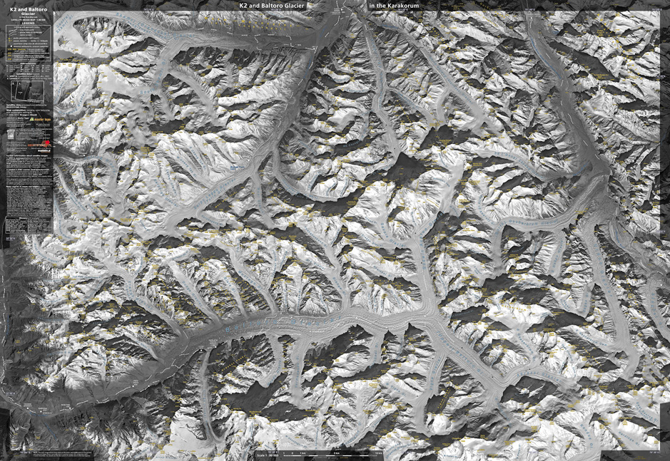
The increase of the number of identified smaller peaks, towers and cols between the 1st and 2nd edition is clearly visible. Only on this section alone there have been added 32 newly identified objects and 30 heights estimated from recent sources or taken from old Soviet military maps (not excluding each other).

* * *

For whole map and its 2nd edition of 2013 the number of identified peaks reaches 1736 while in the 1st edition it has been 1016 (as many times has been placed a triangle symbol of the peak or tower).

The number of identified cols and notches is 290 while in the 1st edition has been 160.

Thus, statistically the increase of the number of identified terrain objects in ridges is more than 70 % from the 1st to the 2nd edition of the map (however, most of these added objects are details of the minor importance and only few of them have names).

Fig. 3. Turnie Trango i lodowiec Trango, dolna część, wydanie drugie mapy (2013).

(obraz nieco powiększony, ok. 1.25 raza w przypadku panoramicznego ekranu 14 cali dla notebooka, 1280 x 800)

Przesuń mysz na obraz aby zobaczyć ten sam wycinek z wydania pierwszego (dla androida: dodatkowo dotknij na ekranie) i przesuń na zewnątrz, aby powrócić

=======================================

There are newly denoted smaller towers and new names (established recently by climbers) on the SW slopes of the Trango Ri II. The new names here are Severance Ridge, I and II tower, Garden Pk, Ibax Pk, Sadu Pk.

Not all known names are added to reduce disturbing the main image.
For example, a few hundreds meters to the South from Garden Peak there is Garda Peak about 4600 m high and only its top as a triangle symbol is denoted; few hundred meters to SE from Sadu Peak one can see a rock triangle shape of BC Wall, climbers warm-up area closest to the Base Camp and not having real peak, so only a shape identifies it.

There have been added next 8 towers on this section of the map, 7 of them unnamed, with given or approximated heights.

Also the name Trango Brangsa was shifted to the most grassy area in the valley with meadows near Shipton BC. The word "brangsa" concerns place convenient to stay by ancient caravans (on the branch of the Silk Road) with some pasture area for pack animals, so this localization of that old name looks more probable, however is still not certain (thus now in parenthesis).

Fig. 4. Rejon K2 i Broad Peak area, wydanie 2 mapy (2013)

Przesuń mysz na obraz aby zobaczyć ten sam wycinek z wydania pierwszego (dla androida: dodatkowo dotknij na ekranie) i przesuń na zewnątrz, aby powrócić

=======================================

Here in this excerpt there are well known giant 8000-meters peaks and the terrain has relatively accurate surveys and maps for a long time and they have been used for the 1st edition of our map. Thus in the 2nd edition for this fragment of map the number of added towers and outcrops is relatively low, however still one and a half dozen (18). Most of small culminations have been added on the slopes of K2 but some next on the slopes of Broad Peak.

There is added also the name of Pastore Peak, an alternative name of the Khalkhal Peak East newly opened for high altitude treks (in fact the secondary SE shoulder of Khalkhal East was christened as Pastore Peak in 1984 to commemorate an Italian climber, but recently both names are treated as synonyms for main peak).

Also Pastore Peak BC have been added and two objects on the normal route to Broad Peak and two names of small glaciers in this massif.

The symbol of K2 Base Camp has been moved for almost 2/3 kilometer towards NE but one should remember that in summer season this BC is a structure more than 1 km long and the move means that now "the center" of the base camp area is shown.

Fig. 5. Rejon przełęczy Ghondogoro La, wydanie 2 (2013)

(obraz nieco powiększony, ok. 1.25 raza w przypadku panoramicznego ekranu 14 cali dla notebooka, 1280 x 800)

Przesuń mysz na obraz aby zobaczyć ten sam wycinek z wydania pierwszego (dla androida: dodatkowo dotknij na ekranie) i przesuń na zewnątrz, aby powrócić

=======================================

Most important on this excerpt is the reduction of the altitude of the Ghondogoro La (Pass) for almost 300 meters accordingly to GPS reports (showing for example 5616 m) and many other reported observations from trekkers and trekking agencies. Thus the altitude of closest objects also should been reduced but now this can be make only approximate and needs further fieldwork research.

Jerzy Wala ideas of introducing the names of Ghondogoro Low La (lowest nearby col, notch, recess, not crossable) and the Ghondogoro High Peak has been supported. Also Ghondogoro Dome has been proposed for small broad ice hump very close to the Pass and sometimes visited for better panorama but unadequately called as the "peak".

There are also added 7 points and heights and one name of the glacier on this section of map.

* * *

In general in the 2nd edition the shadow parts are given little bit brighter on the whole map so the terrain in shadows is better explained. Thanks to this, on this section of the map the line of the main trek route has been slightly corrected in the shadows on northern slopes.

Fig. 6. Ziemia nieznana, rejon Durbin Kangri, wydanie 2 mapy (2013)

Przesuń mysz na obraz aby zobaczyć ten sam wycinek z wydania pierwszego (dla androida: dodatkowo dotknij na ekranie) i przesuń na zewnątrz, aby powrócić

=======================================

The prominent mountains of Durbin Kangri and Durbin Kangri II belong to still unexplored by climbers Aghil Mountains and arise to the east from the oasis of Durbin Jangal in the Shaksgam valley.

In the 1st edition these both peaks have not been identified by the names, presently they have. On this excerpt from the map there have been added also 9 points and heights, 4 minor cols and one symbol of the big water cave. Also some further amendments have been made. For example, look at the correction on the relative position of three highest points of the Durbin Kangri II (now the central one appears to be the highest one).

The Shaksgam River has many variant names so few more ones have been added on the map (Kulchin, Kelechin, Kerching etc.) for the better compatibility with other available sources.

* * *

These massifs still await for serious researchs by contemporary mountaineers. The first widely reported trek with serious GPS records which went along the ravine between Durbin Kangri I and II took place only in 2010 (5-men team had crossed the pass to the SE and reached the Zug-Shaksgam River). The river arising from the cave was observed and photographed by the same expedition.

The mountains seem to be of dolomite and limestone ("dolomite type" as was described by earlier travellers from distance). Also the cave suggests that there is potentially karstified area. The altitude difference between high plains and Shaksgam river is about 1600 m while the total difference between highest peaks and Shaksgam reaches 2800 m.

Steep snow and rock faces including NE face of Durbin Kangri reach the height of about 1800 m and are still virgin.