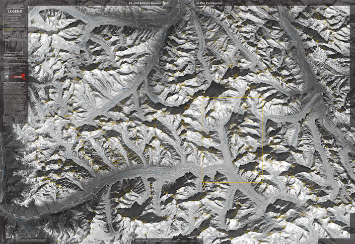
Satellite Image Map 1:80 000
The K2 and Baltoro Glacier Satellite Image Map 1:80 000 appeared in winter 2004/2005. The basics is an image acquired by the satellite SPOT 4 from the height of ca. 820 km with ground resolution of 10 m per pixel, delivered and processed by Geosystems-Polska. All composition, added data and identification of all named or officially measured points is by Grzegorz Glazek. The map covers area ca. 74 x 58 km, the names are in color, longitude and lattitude described on margins in 10' intervals. There are also denoted trek routes, usual campsites and seasonal settlements.
The legend (in English) includes also small glossary (in Urdu, Balti and Chinese), bibliography on the main sources of names and heights as well as some further technical details about the satellite image.
The map was published by the PZA (Polski Zwiazek Alpinizmu, Polish Mountaineering Association). ISBN 83-910339-7-X, format 99 x 68 cm (39 x 27 inches, near B1). There are folded versions (with strong PPE pocket 13 x 24 cm, ca. 5 x 10 in.) on thiner paper and rolled ones on thicker paper.
Reviews and opinions:
• The map has professional review in American Alpine Journal annual (AAJ 2005, pp. 459-460) which ends with the following sentence: "They would do well to use Grzegorz Glazek's K2 and Baltoro Glacier map as a model."
• The map was announced earlier in British monthly High (no. 258, May 2004, pp. 59, 60), later Climb (no. 7, Sept 2005, p. 73).
• On the page TheMountainCompany.co.uk (pdf file, p. 18) of the British organizer of treks along Baltoro to Hushe one can find such opinion in the trip dossier about the maps: "K2 and Baltoro Glacier Satellite Image Map 1:80,000 (Geosystems) – this is
the best map of the area with superb satellite photography. (...) I will bring this map along
on the trek."
- Baltoro map - review from AAJ 2005
- Baltoro map - Dunge Gl., Trango Towers - enlarged detail
- Baltoro map - Broad Peak, Concordia to K2 - detail
- Baltoro map - field opinion from the British organizer of treks [link not valid] TheMountainCompany.co.uk (pdf, page 18)
- Stanfords.co.uk (both versions; flat - item 133834)
- Cordee.co.uk (both versions; flat - item CMW517)
- Omnimap.com (item 65-1375)
- Chesslerbooks.com
- Mountain-bookshop.de (item 6023)
- Nomaden.no
- PizBuBe.ch (search => 'Asien', than => 'K2 and Baltoro
satellite map', produkt 4354) - TheMapShop.co.uk (search => 'Pakistan', other maps)
(or contact us) (distribution in Poland: see version in Polish)